Get Topographic Map Scales for Surveying and Geology
Why Topographic Map Scales Are Crucial for Surveying and Geology
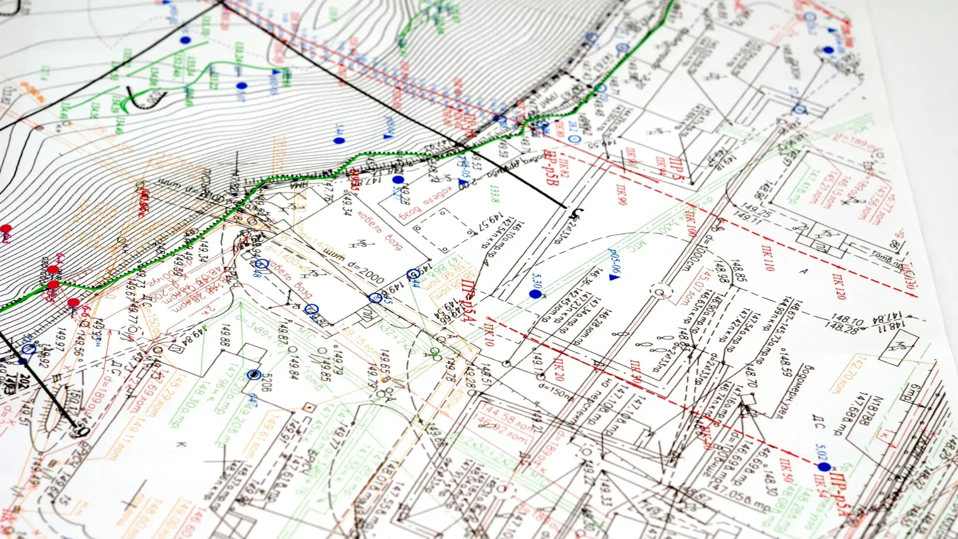
Topographic maps are essential in surveying and geology. They show landforms, elevations, and other terrain features. These maps help professionals understand the shape of the land. They are crucial for measuring distances, slopes, and contours accurately.
Accurate measurements are necessary for reliable survey data. In geology and construction, precise measurements ensure that projects are successful. For example, when designing roads or bridges, surveyors need to know the land’s elevation and slope. Without correct data, mistakes can occur, causing delays or added costs.
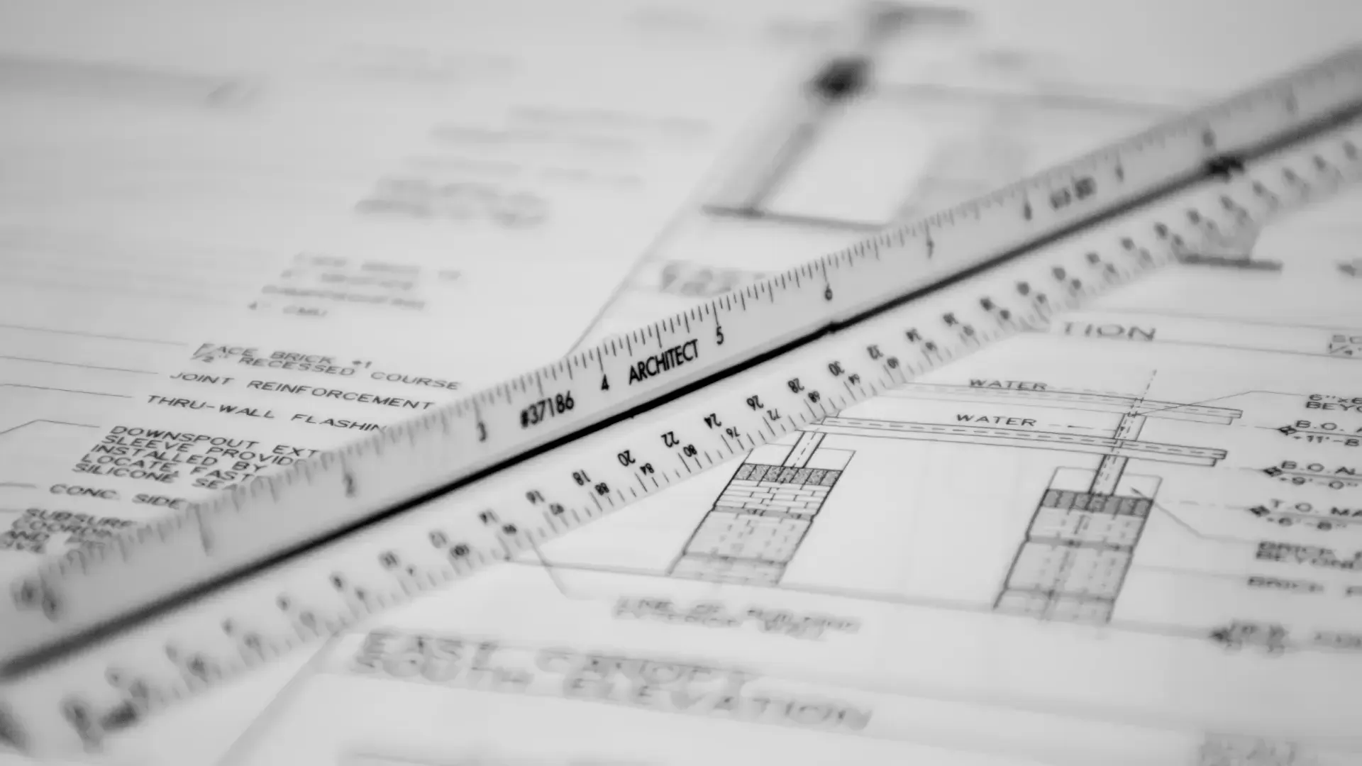
Topographic map scales make all of this possible. They help geologists and surveyors measure distances on maps that represent the real-world terrain. By using the right scale, they can read the details that are important for their work. A proper scale makes sure measurements are clear and consistent. This helps avoid errors and improves the planning process.
In both geology and surveying, choosing the right topographic scale is key. The correct scale can mean the difference between a smooth project and one full of problems. Whether it’s for construction or geological study, these scales provide the accuracy needed for success.
Benefits of Using Topographic Map Scales for Surveying and Geology
Topographic map scales help professionals measure the land accurately. They make it easier to determine slopes, elevations, and other terrain features. Surveyors rely on these scales to measure distances and ensure their data is precise. This is important for any project that involves land development, construction, or planning.
For surveyors, accuracy is essential. Using the right scale ensures that measurements on maps match the real-world distances. This helps in planning and designing land use, roads, and buildings. Mistakes in scaling can cause delays and mistakes, which are costly to fix.
Geologists also depend on topographic map scales to understand the Earth’s surface. The contours and elevation markings show how the land is shaped. This helps geologists analyze rock formations, soil types, and land behavior. They use this information to predict how the land will change over time.
In addition to improving accuracy, using topographic scales helps save money. By reducing errors, these scales cut down the need for rework. This is important for both surveying and geology. It helps keep projects on schedule and within budget.
A study from the Journal of Surveying showed that accurate maps prevented costly mistakes in a major project. This proves that topographic scales can improve both project outcomes and efficiency.
How to Choose the Right Topographic Map Scale for Your Project
Choosing the right topographic map scale depends on the size of your project. For larger areas, like regional surveys, a scale like 1:24,000 works well. It gives you enough detail to plan roads, land use, and other structures without being too detailed. On the other hand, smaller scales like 1:100,000 are better for general, less detailed analysis.
The level of detail you need is another factor to consider. If your project requires a close look at specific geological features, you’ll need a scale with more detail. A 1:25,000 map scale is great for geological investigations. It allows you to see smaller variations in terrain and analyze specific features more closely.
Digital maps are becoming more common in surveying and geology. These maps are often compatible with GIS software, making it easy to integrate data and analyze maps digitally. You’ll need to decide whether you prefer printed maps or the flexibility of digital formats for your project.
Different projects require different scales. For example, if you are focusing on detailed geological features, a 1:10,000 scale map is ideal. However, for broader land surveys, a 1:50,000 scale will suffice. Understanding the scope of your project and the level of detail needed will help you choose the right map scale.
Where to Buy Topographic Map Scales
Finding reliable topographic map scales starts with choosing the right supplier. You need a company known for precision and quality. Suppliers like Multiscale Products specialize in durable, accurate map scales for surveying and geological work. They offer a variety of scales, designed to meet the needs of professionals in the field.
Shopping online makes it easy to compare different map scales and find what you need. Many suppliers provide detailed product descriptions and easy ordering. Look for options with clear return policies and product warranties. This gives you peace of mind that your purchase will be correct and dependable.
If you want something more personalized, consider customization. Multiscale Products offers the ability to add logos or company information to your map scales. This can be a great option for businesses or teams who want their tools to reflect their brand.
For help choosing the right scale, reach out to customer support. Good suppliers provide strong after-sales service, helping you with any questions or concerns. With the right supplier, you can be sure you’re getting the best tools for your project.
Contact Us for Expert Advice or Custom Orders
Have specific needs or looking for custom solutions? Reach out to us for expert advice or to place a custom order.
Frequently Asked Questions
What is the difference between topographic map scales and other types of map scales?
Topographic map scales show how a specific distance on a map compares to the real world. For example, a scale of 1:24,000 means one unit on the map equals 24,000 units on the ground. Unlike regular maps, topographic maps also display land features like elevation, slopes, and contours.
How do I choose the right scale for my geological survey or construction project?
It depends on the area and detail you need. For large regions, a smaller scale like 1:100,000 is suitable. If you need more detail, choose a larger scale, like 1:25,000 or 1:10,000. Consider the level of detail required for your project when picking a scale.
Can I use topographic scales for both small-scale and large-scale mapping projects?
Yes, you can. For large-scale projects, use smaller scales (e.g., 1:100,000). For smaller areas or more detailed work, use larger scales like 1:25,000. The right scale depends on the size and detail of the area you are mapping.
Are digital topographic scales available for GIS and other software?
Yes, digital topographic scales are available. They can be used with GIS software and other digital mapping tools. These digital scales provide the same accuracy as printed ones and are easy to integrate into your digital projects.
Conclusion
Topographic map scales are vital for accurate surveying and geology. They help professionals measure terrain features like slopes and elevations. Without them, collecting precise data would be nearly impossible.
If you’re ready to get started, take a look at our selection of topographic map scales. We offer high-quality options for every project. Need help choosing the right one? Contact us today for expert advice or shop now for fast, reliable service.
Shop Now for Topographic Map Scales
Ready to take the next step? Shop now for topographic map scales that guarantee accurate land measurements for your surveying and geological needs.